Google Earth shows devastation in Gaza post-war
Satellite images updated by Google Earth and Google Maps show the scale of destruction in the Gaza Strip after two years of war between Israel and Hamas. The comparison between August 2023 and February 2026 went viral on social media and shocked internet users. UN data indicates that 82% of the territory's structures were damaged.

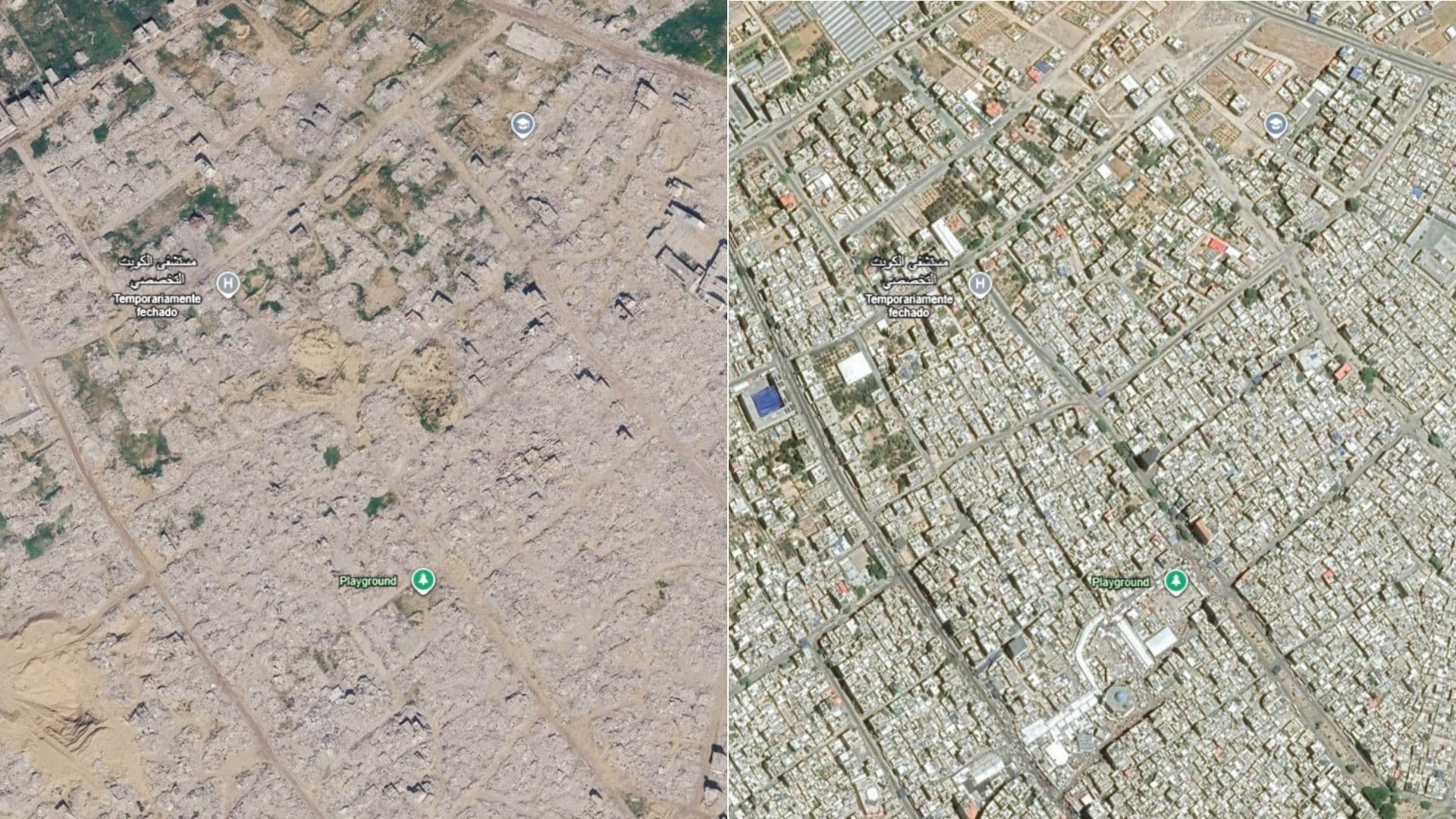
Satellite images of the Gaza Strip posted by Google Maps and Google Earth went viral over the weekend on social media. The photos, which show the scale of the devastation in the post-war Palestinian territory, shocked netizens. The comparison between August 2023 and February 2026 reveals the scale of destruction caused by two years of conflict between Israel and the terrorist group Hamas.
The images are the first Google satellite images to show the destruction of Gaza in high definition. The territory was devastated between October 2023 and October 2025. Social media posts with satellite photo prints added millions of views. One of them is Barry Andrews, a politician in the European Parliament, in which he said that the images are impressive and now available "for everyone to see".
Comparative reveals drastic change in the landscape
The comparison shows Google Earth satellite images of the city of Rafah in the Gaza Strip in February 2026 (post-war, left) and August 2023 (pre-war, right). The difference is striking: previously densely built areas now appear as razed grounds, with debris scattered over entire blocks. The 2023 image shows streets, buildings and vegetation; the 2026 image reveals a scenario of widespread destruction, with few standing structures.
Google Maps and Google Earth recently updated the satellite images of the Gaza Strip that appear on their platform. The new photos, which show the scale of the devastation in the post-war Palestinian territory, shocked netizens and went viral on social media over the weekend. The update was the first in more than a year, the Spanish newspaper El País reported.
UN data scales up destruction
The United Nations Satellite Centre (UNOSAT) said in August that 82 percent of all structures in Gaza had suffered some kind of damage as a result of the war, with two-thirds of them completely destroyed. That’s more than 60 million tons of debris, according to an analysis by the BBC. The scale of the destruction is unprecedented in the region and raises concerns about the reconstruction of the territory.
The war between Israel and Hamas began on October 7, 2023, when terrorists launched an attack that resulted in the deaths of more than 1,200 people and the kidnapping of 251. Since then, more than 70,000 Palestinians have died in Gaza, according to Palestinian health officials linked to Hamas. The conflict lasted for two years, until the peace agreement signed in October 2025.
Divergence on the date of the images
The timing of the satellite images being updated on Google’s platforms was still uncertain until the last update of this report. The US magazine Newsweek claimed that Google told the vehicle that the new images were from July 2026. Google Earth states on its website, however, that the images are from February 2026, while Maps speaks only of “2026.” A visual analysis made by g1 found that the satellite photos used on both sites have great similarity.
Despite the divergence over the exact date, the images are clearly post-war after the large-scale fighting ended. They show the result of months of bombing and military operations that have reduced entire neighborhoods to rubble. The public availability of these images allows anyone to visualize the extent of the damage, something that was previously restricted to reports from humanitarian agencies and drone images.
Political impasse and military presence
Despite the peace agreement between Israel and Hamas in October 2025, Israeli troops remain in Gaza and control most of the territory with a security cordon. The Netanyahu government and the terrorist group are currently at a standstill. Gaza’s reconstruction has not yet begun significantly, and the local population faces precarious humanitarian conditions, with limited access to water, food and basic services.
Satellite imagery serves as a visual record of the crisis and can influence the international debate about responsibility for reconstruction and the future of the territory. The viralization on social networks brought the issue back to the center of discussions, with reactions from political leaders and humanitarian organizations. The international pressure is expected to increase for the parties to reach a lasting agreement and begin the recovery of the region.
The Boca no Trombone Portal will continue to monitor the developments of this situation and will bring new information as it is confirmed by official sources. In the meantime, we invite readers to explore other reports on international conflicts and their humanitarian impacts on our website.
Read Also
Former Snooker World Champion Convicted of Pedophilia
Font
g1.globo.com